Blog Archives
Exploration around and through the Barranco de Tágara
Posted by Sally Whymark
Apart from the walk I did on August 8th, 2012 (see the gallery of photos posted on this blog then), I have not walked in the area of the Barranco de Tágara since the devastating fire there nearly a year ago. However, I had been interested in doing so while the forest is more open than before, as my friends and I believed there were paths there we did not know, and finding and exploring them would be easier. So yesterday we went to search out new paths.
We set out from the Mirador de Chio, or Narices del Teide, near km3 on the TF-38 from Boca de Tauce to Chio and walked a little way up the road towards Boca de Tauce and turned right onto a track heading across the malpais (aa lava flow) towards the caldera wall. On the caldera wall I spotted the La Palma groundsel (Senecio palmensis) hanging from a cleft in the cliff. It is an endemic of La Palma, but also of Tenerife. In the malpais were clumps of Shrubby scabious (Pterocephalus lasiospermus), now in full flower.

A fine specimen of Shrubby scabious (Pterocephalus lasiospermus) in the malpais near the start of the walk
The track bends around to the left and on the bend below the cliff was a clump of the endemic Tenerife campion (Silene nocteolens). There were quite a few specimens in the area, mostly beneath rocks or rocky cliffs.
We made our way to the fire vigilance watch-tower at the back of Mt Cedro, the focus of a popular walk for our walking group – before the fire, of course. From there we took a path that was renovated not so long ago, heading downhill. It is now well defined, unlike when I first tried to follow it, upwards, before it was renovated! However, we had not gone very far down it when we came across a group of cairns, and some white paint spots, drawing our attention to a path going left which we had never seen before. We had a little discussion and decided to follow it.
The path headed left along the head of the Barranco de Tágara, with fine views down into it, from directions I had never seen before. It was not the best path ever, but was easy to follow with plenty of cairns and white paint spots. Having crossed the barranco head it headed downhill, getting steeper, and was a bit loose underfoot here. The last couple of hundred yards the cairns and markings disappeared, but we could see a track ahead and just made our way down to it. We found ourselves on a bend in the track where the path from Boca de Tauce to Guia de Isora, the PR-TF 70 passes very close, at point 7 in Walk 9 of the book ‘Tenerife Nature Walks’. This is where that path intersects a path shortcut, which we took, and this resulted in us ending up at point 12A of that walk.
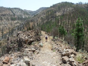
We were now in the Barranco de Tágara itself, beneath its mighty cliffs and surrounded by trees with deeply charred bark and branches, but amazingly mostly still alive. It is a testament to the resilience of the Canary Pine (Pinus canariensis) that it can survive even such an intense fire as was concentrated in that Barranco last July. A few giant trees which had fallen due to the fire, and which last August we saw still burning, had, of course, died, but the vast majority are sprouting new green shoots up the trunks, giving hope for the future. Meanwhile it still looks a little bare on the ground, although there clearly had been a good showing of Teide marguerites (Argyranthemum teneriffae) this spring, now mostly over. Other ground flora is regenerating rapidly, including Teide wallflowers (Erysimum scoparium) and Pine forest cistus (Cistus symphytifolius), so next spring should have a great show in the Barranco.
We followed the yellow/white marked PR TF-70 through the Barranco and found the path had been cleared of obstacles such as fallen trees, rocks, etc, which we had encountered last August. There were some rough bits, especially crossing a near vertical streambed, just after passing the Galeria (water mine), but it was all walkable.
However, as we left the barranco and turned the corner, we found a burnt tree across the path at head-height – easily ducked under – and soon afterwards a huge burnt tree still lying across the path at the point the path from the firetower joins the PR TF-70. It was easily skirted around, but I was surprised it had not been trimmed so the path was clear.
We continued to follow the PR TF-70 path, crossing the Barranco Peguerias, where you still have to go a little way down the streambed to get up to the path on the other side. Out of that barranco the path rises gently till it reaches the crest of a ridge where a signpost points the PR TF-70 downhill. This was where we left that path, as we wanted to explore a path going up the ridge. I had thought it likely this was a minor path, although looking down from above we had been able to see it clearly. It turned out to be a well-constructed proper path with steps in places, and rain-gutters too, so it was a pleasure to walk.
As expected, the path joined another path I have walked only once or twice, which crosses the Barranco Peguerias higher up than the PR TF-70. However, we did not turn right at that point to cross that barranco, but went left to cross the Barranco del Cedro, zig-zagging up the far side till we reached the track which accesses the Galeria Salto Gutierrez. The track was a bit overgrown and had some large rockfalls across it, showing it had not had vehicles along it for a long time. As we went along it we discovered why – Charaquete – had washed the track away, though we were able to cross on foot without much trouble.
After that barranco we started looking for the path to go back up to where we started. However, we walked right past it as it was badly eroded, and the cairns had fallen. Fortunately the track did a hairpin bend and crossed the path again, where we did see the cairns for the path and started following it up. At first it was very steep, and with the erosion of the path, needed a lot of effort and concentration in placing of feet, but higher up it was less steep and was easier walking, till we reached the malpais. In the malpais it was harder to see the path, and the cairns, but they were there and guided us to a new bit of National Park path, very clearly delineated, on which we went left.
The National Park path clearly replaced the previous path I had on which I crossed the malpais several years ago, and it wound its way to the road right opposite the Mirador where we had parked. We had seen the signboard for the path when we started, but had not seen the path, which went to the right from the signboard behind the crash barrier.
The route took us around 6 hours, was 15.4km long and involved 622m of climbing.
Posted in Teide National Park, Teide National Park, West Tenerife
Tags: Argyranthemum teneriffae, Barranco de Tagara, Barranco del Cedro, Barranco Peguerias, Boca de Tauce, Bystropogon origanifolium, Firetower, hiking, Mt Cedro, paths, Pimpinella cumbrae, PR TF-70, Pterocephalus lasiospermus, Robber flies, Senecio palmensis, Silene nocteolens, Tenerife, walking


